-
Mods are now organized as resources. Use the Mods link above to browse for or submit a mod, tool, or prefab.
The TFP Official Modding Forum Policy establishes the rules and guidelines for mod creators and mod users.
You are using an out of date browser. It may not display this or other websites correctly.
You should upgrade or use an alternative browser.
You should upgrade or use an alternative browser.
A19e Nitrogen - UNSTABLE
- Thread starter Damocles
- Start date
- Status
- Not open for further replies.
Awesome!
Would love to chat with you regarding your generation approach. I'm still actively working on my generator too, I've gone down a detour a bit because I thought it would be interesting to generate a map with a maze in it, but I'm pretty much up to generating roads and towns, would love to hear your thoughts.
Would love to chat with you regarding your generation approach. I'm still actively working on my generator too, I've gone down a detour a bit because I thought it would be interesting to generate a map with a maze in it, but I'm pretty much up to generating roads and towns, would love to hear your thoughts.
Damocles
Refugee
Some technical details:
[POIs]
The POIs are selected from an included list, in a format such as this:
skyscraper_01,DOWNTOWN,2,-1,93,134,87,citycenter
(Name, 7dtd zone, face-north-direction, y-offset, wide (x), high") , deep (z), NitroGen zone
, deep (z), NitroGen zone
the zone defines where it will be placed (on mountain, on a farm, only in cities, in trailerparks)
New POIs can be added simply by inserting a new entry with the Prefabs name, and its dimensions (can be seen in the prefab editor).
NitroGen can load any POI included with the game, so its also using several from Navezgane and some good looking work-in-progress POIs.
The POIs are placed onto the terrain at its chosen location (depending how high that settlement is allowed to be). Since the POIs have a very rigid base-floor, the terrain is smoothed to a plateau at this location. Else they would hang in the air, and we dont want that the happen ...
[ROADS]
Here a preview map that can be generated: (8K map, generates in about 4 minutes)
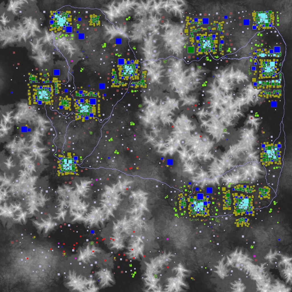
The roads are placed between cities. They use classic map pathfinding (similar to A*) to find the route with the shortest distance, but also the least elevation change... just like people would build roads.
Then they smooth out the terrain a bit along the path and place the road-splatmap textures.
I have written the pathfinding algorithm within a few minutes as a prototype, and did not optimize it yet. A proper A* would be quite a bit faster...
-----------
The terrain hightmap is first rendered to a normal 8 bit png. Then processed by the POI mapper (roads and POI plateaus), then exported to the 16bit RAW hightmap and smoothed over.


[POIs]
The POIs are selected from an included list, in a format such as this:
skyscraper_01,DOWNTOWN,2,-1,93,134,87,citycenter
(Name, 7dtd zone, face-north-direction, y-offset, wide (x), high
, deep (z), NitroGen zonethe zone defines where it will be placed (on mountain, on a farm, only in cities, in trailerparks)
New POIs can be added simply by inserting a new entry with the Prefabs name, and its dimensions (can be seen in the prefab editor).
NitroGen can load any POI included with the game, so its also using several from Navezgane and some good looking work-in-progress POIs.
The POIs are placed onto the terrain at its chosen location (depending how high that settlement is allowed to be). Since the POIs have a very rigid base-floor, the terrain is smoothed to a plateau at this location. Else they would hang in the air, and we dont want that the happen ...
[ROADS]
Here a preview map that can be generated: (8K map, generates in about 4 minutes)
The roads are placed between cities. They use classic map pathfinding (similar to A*) to find the route with the shortest distance, but also the least elevation change... just like people would build roads.
Then they smooth out the terrain a bit along the path and place the road-splatmap textures.
I have written the pathfinding algorithm within a few minutes as a prototype, and did not optimize it yet. A proper A* would be quite a bit faster...
-----------
The terrain hightmap is first rendered to a normal 8 bit png. Then processed by the POI mapper (roads and POI plateaus), then exported to the 16bit RAW hightmap and smoothed over.
Last edited by a moderator:
n2n1
Survivor
So.... You made an RWG generator?...
I'd like to check it out, but I'll wait in the hope that it stops requiring a separate Java...
... so, it uses its own terrain algorithms? All this seems rather complicated...i'm even confused...
Hmmm....is 32K mode possible for crazy Russians?...(or there is a limit in the game itself?)
I'd like to check it out, but I'll wait in the hope that it stops requiring a separate Java...
... so, it uses its own terrain algorithms? All this seems rather complicated...i'm even confused...
Hmmm....is 32K mode possible for crazy Russians?...(or there is a limit in the game itself?)
Last edited by a moderator:

Damocles
Refugee
EDIT: I think i know what happened: Did you start it from within the zip file? It needs to be extracted first.
It has the same behavior when I do that, then not using it installation directory by using the system path.
If not, there is still an issue for it to use relative paths.
i will have a look into that.
Try to get into the directory with the jar via the commando line, and enter
java -jar nitrogen.jar
the should make it have the right local path.
---------------
For such large maps, the approach how to create the output files would have to be reworked, creating it in small chunks.
unforunately the game requires to have everything in one large file. (terrain, splat maps, etc) and does not split it into smaller chunks at world-generation. but you can populate the maps with a LOT of POIs, making the world more filled than the vanilla RWG. Several thousand POIs should give everyone a good playfield.
It has the same behavior when I do that, then not using it installation directory by using the system path.
If not, there is still an issue for it to use relative paths.
i will have a look into that.
Try to get into the directory with the jar via the commando line, and enter
java -jar nitrogen.jar
the should make it have the right local path.
---------------
32K would likely blow the memory. 16k is already quite taxing on it.Hmmm....is 32K mode possible for crazy Russians?...(or there is a limit in the game itself?)
For such large maps, the approach how to create the output files would have to be reworked, creating it in small chunks.
unforunately the game requires to have everything in one large file. (terrain, splat maps, etc) and does not split it into smaller chunks at world-generation. but you can populate the maps with a LOT of POIs, making the world more filled than the vanilla RWG. Several thousand POIs should give everyone a good playfield.
Last edited by a moderator:
Damocles
Refugee
I will fiddle around with the paths a bit. Lets see if this helps.I had unzipped it and clicked on the .jar file that's associated with java. I'll try the line item, but the 8k map did "more", it just never got around to generating the map. =)
- - - Updated - - -
Can you see a bug coming up the the console (F1) in 7DTD?Works for me on 4k, but nothing on 8k.
Though when playing on the 4k world I generated it has crashed 4 times in 1 hour
You could try a map that places less POIs, it might be a resource problem, or the map instantiated a POI that is not in your games prefab folder.
It loaded all of them in my vanilla 17.2 installation.
n2n1
Survivor
Big worlds are just needed in order not to fill their POI, but to have a lot of space for travel.//// but you can populate the maps with a LOT of POIs, making the world more filled than the vanilla RWG. Several thousand POIs should give everyone a good playfield.
You plan later to compile the project that he did not use the external Java?
Last edited by a moderator:
Damocles
Refugee
I have just uploaded Version 0.11. (same link)
It handles file-path a bit differently and checks for the resources before starting to generate the map.
Hope this helps to track down issues with the working directory.
- - - Updated - - -
(It would also increase the filesize quite bit to have Java included in the Installation, Java is quite bloated.)
It handles file-path a bit differently and checks for the resources before starting to generate the map.
Hope this helps to track down issues with the working directory.
- - - Updated - - -
I can later bundle it with a Standalone Java implementation. But not for now.Big worlds are just needed in order not to fill their POI, but to have a lot of space for travel.
You plan later to compile the project that he did not use the external Java?
(It would also increase the filesize quite bit to have Java included in the Installation, Java is quite bloated.)
Last edited by a moderator:
Damocles
Refugee
They are not really "smooth", but thats also on purpose, as I dont want the roads to looks like artificial cuts on the terrain.Do you find your roads smoother than vanilla?
...Consider them badly maintained local roads of a poor county..
The roads will have some very steep angles on very steep terrain, but in general are way smoother than the surrounding landscape.
And they are actually "build" after the terrain was generated and populated, so they can make large curves around mountains, go though valleys, avoid lakes and existing POIs.
There are still some issues when they meet the first POI of a city on higher terrain, as they might steel some soil from the POIs, wich are where placed already on flattened terrain.
Later I could include some more country side roads between towns, when the pathgeneration works faster. They are quite demanding to generate the more settlements there are.
Last edited by a moderator:
Hey mate,
Looks really awesome, I'm definitely going to download and try.
Hey, I'm up to doing the road generation in my program, could you share any insights as to what to research for the path finding? Like is the algorithm called something specific? Also, it looks like you're using some kind of erosion algorithm? something I've also struggled to find a decent example of.
Cheers mate.
[Edit] Yeah, nevermind on the path finding, what kind of name is A*!!
Last edited by a moderator:
Damocles
Refugee
Not used here, but a very interesting demonstration of using erosion on a Unity terrain ... if you want to try out dynamic erosion.Hey mate,
Looks really awesome, I'm definitely going to download and try.
Hey, I'm up to doing the road generation in my program, could you share any insights as to what to research for the path finding? Like is the algorithm called something specific? Also, it looks like you're using some kind of erosion algorithm? something I've also struggled to find a decent example of.
Cheers mate.
[Edit] Yeah, nevermind on the path finding, what kind of name is A*!!
https://github.com/SebLague/Hydraulic-Erosion
---
For A* there are lots of tutorials. Its quite straight forward here:
-have a hightmap representation in memory
-scale it down to a usabe size (I have used a quarter of the hightmaps resolution)
-mark the position of POIs and other areas that should be avoided (by increasing the hightvalue on those areas)
-make a path between POIs (between towns), the heuristic used here are distance and elevation change.
-follow the path, and smooth the terrain along the way on the original hightmap
-in parallel draw the road splatmap pixels (there are only 2 road texture types I know of, so 2 pixel colors for the splatmap). There are some random pixels left out to make it a bit more jagged and looking overgrown.
ZanySerendipity
Refugee
My daughter downloaded your map generator last night, and we played a multiplayer game for a few hours. Thanks for sharing this - it's so much nicer to start a map knowing it's not going to end up being over half burned and wasteland. It did take a while for me to download the map once she'd started it, but it worked just fine.
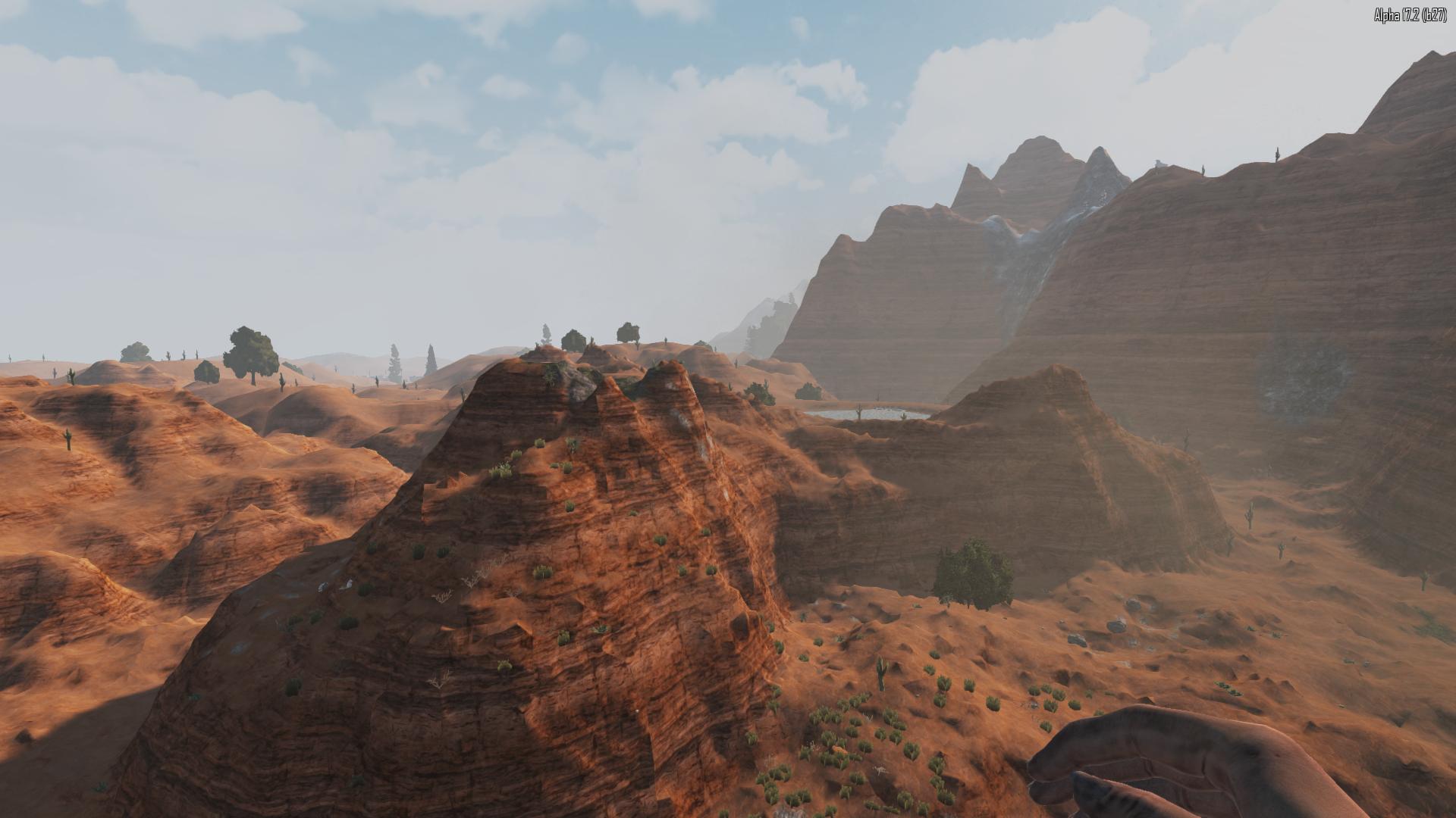
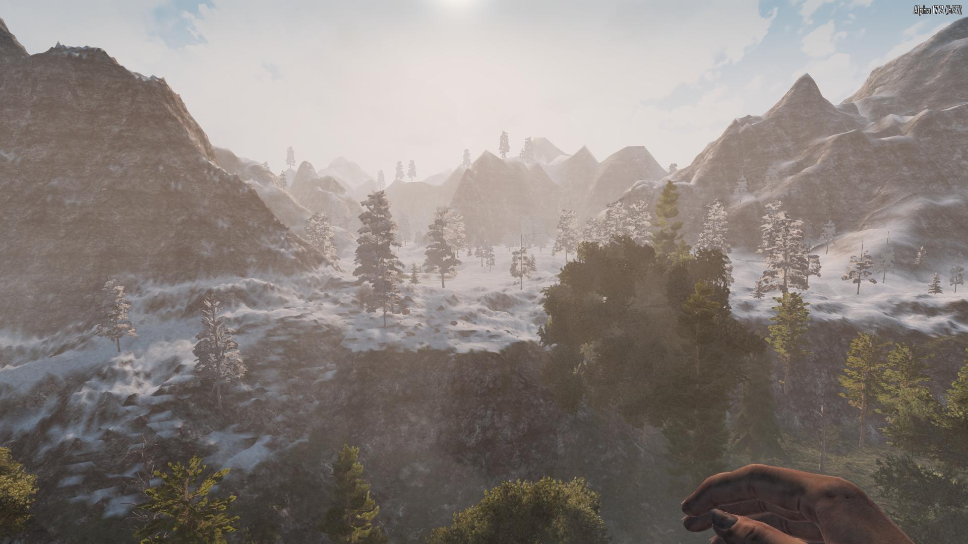
The ground outside the settled areas is quite... rugged. Some high hills/mountains, yes, but also just a lot of bumpy ground. Not necessarily a bad thing, mind you, but it made running across the wild areas visually challenging.
The ground outside the settled areas is quite... rugged. Some high hills/mountains, yes, but also just a lot of bumpy ground. Not necessarily a bad thing, mind you, but it made running across the wild areas visually challenging.
Yeah, since posting I did some reading on it. And I can see why it would be slow. Even still I'm going to give it a shot.Not used here, but a very interesting demonstration of using erosion on a Unity terrain ... if you want to try out dynamic erosion.
Damocles
Refugee
Good to hear that you both had a good time.My daughter downloaded your map generator last night, and we played a multiplayer game for a few hours. Thanks for sharing this - it's so much nicer to start a map knowing it's not going to end up being over half burned and wasteland. It did take a while for me to download the map once she'd started it, but it worked just fine.The ground outside the settled areas is quite... rugged. Some high hills/mountains, yes, but also just a lot of bumpy ground. Not necessarily a bad thing, mind you, but it made running across the wild areas visually challenging.
That what I make those tools for.
You could generate a random map without the rough terrain (only mountains, flat land and forests). Thats the advantage of having configuration options in an RWG.
And also place more or less POIs, depending on how much you want to spend on walking through the terrain.
Wasteland and buring forest biomes are not generated. I just dont think they are making the game any better, and basically just annoyed me, every time I was in them.
i could add maybe a few small patches of burned forest here and there...
Last edited by a moderator:
- Status
- Not open for further replies.