As long as you have the bridge lines commented out in the Read POI Property List, it should be enough to prevent them from appearing. Without those lines, Teragon shouldn't try to place them, just like removing any POI from that list (or from an Import POI Property List command) will prevent a POI from appearing. If it still appears, that seems like a bug that others don't seem to be seeing.
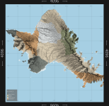
Here are a few maps from Teragon that I made using an imported heightmap. They look really great, though coasts (ocean, lake, etc.) aren't always correctly defined - probably because the heights of those coasts are too close to that of the water or even under the level of the water so the heightmap isn't clear enough. Still, they look great. I wouldn't want to try driving around the Oahu map, though. Maps are Oahu, Hawaii, lower peninsula of Michigan, and the third I don't remember where it was from.
Tricks for Importing Heightmaps
- Heightmap size needs to be the same as your map, so resize it if necessary.
- Heightmaps should be in grayscale and will work in 16bit and 32bit. Not sure about others as I haven't tried any others. You can convert a map to the right type using various image editing software.
- Some heightmaps will have the base land height at close to 0 height, so you will likely need to make adjustments to the flat water map to get the water where you want. You can use Scale Heightmap to raise the base land height to a more reasonable height.
Also note that the time to generate a map if you import the heightmap is significantly faster than normal. I can generate a map using an imported heightmap in 30-90 seconds rather than 5-15 minutes (time varies based on things like amount of lakes and such). If you like a map, you can export the heightmap and then import it to make adjustments to things like towns and POI and water and even rivers or roads without having to spend a long time recreating the heightmap each time. It can save you a LOT of time once you have an overall terrain that you like, so starting with just a basic terrain map with nothing on it first until you get something you like, then exporting the map, you can then import it and try a variety of changes without waiting as long.
View attachment 27272
View attachment 27273
View attachment 27274


